The Northeast United States is prepared for extreme weather, including possible snowfall, as a huge storm moves up the East Coast, with sections of North Carolina and Virginia under tornado watch.
According to the National Weather Service, heavy wind and extreme rainfall are predicted to approach the Northeast and the mid-Atlantic coast by Sunday evening, with snow likely to fall across the northern Appalachians and interior Northeast.
According to the NWS, temperatures will also fall as a cold front moves across the Midwest and East Coast.
According to the NWS, there is a minor danger of “damaging wind gusts” and “a few tornadoes” across sections of the eastern Carolinas and southeastern Virginia, as well as parts of northern Florida and southern Georgia.
Related Posts

A tornado warning has been issued for sections of North Carolina and Virginia until 8:00 p.m. ET.
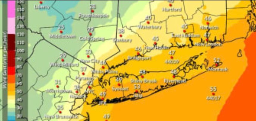
According to the governor’s office, “several” inches of rain and severe gusts are forecast in the Long Island, New York City, and lower mid-Hudson districts of New York. Flooding and power outages might be caused by the weather.
According to Hochul, up to 3 inches of rain and 50 mph gusts are forecast in New York City.
According to Hochul, heavy, wet snow fell Sunday night in the North Country, Mohawk Valley, central New York, Capital District, and upper mid-Hudson regions, disrupting traffic and perhaps causing power outages.
New Jersey Gov. Phil Murphy said on the social media site X that across the state, “localized flooding and severe thunderstorms” are expected. He added that snow is possible in the northeastern parts of the state.
Hochul urged New Yorkers to be prepared by paying attention to weather updates and planning any travel accordingly. Murphy encouraged New Jersey residents to stay at home, but to drive slowly and exercise caution if they have to travel.