Political News:
CLOSE
![]()
With nearly 50 million people expected to drive to their Thanksgiving destinations, active weather patterns around the country may cause problems.
Accuweather
A powerful winter storm that dumped heavy snow from the Central Rockies to the Upper Great Lakes – including a foot around Minneapolis – weakened Thursday as it moved to the northeast.
But forecasters say a second storm, already pummeling California, could disrupt travelers, particularly in the northeast and mid-Atlantic states, as they begin heading home on Sunday.
Weather Channel forecasters warned of the possibility of end-of-holiday travel delays from wet or snow-covered roads and flight delays because of low pressure moving into the East.
The forecast calls for snow mainly in New York state and New England, with rain possible from the mid-Atlantic to the Southeast. The Midwest should still be coping with lingering snow as the weekend winds down.
Holiday travel basics for infrequent flyers: 6 things to know if you haven’t flown lately
While the first system, which hit early this week, was still expected to produce mighty gusts across much of the Northeast, it fell short in Manhattan, allowing organizers of the annual Macy’s Thanksgiving Day parade to permit the iconic balloons to float above the crowds as the floats wound their way through New York City streets.
Under parade rules, the balloons are lowered, or even grounded, when sustained winds exceed 23 mph and gusts exceed 34 mph.
UPDATE: NB/SB I-5 between Yreka and Redding remains CLOSED due the extremely large number of vehicles spun out along the interstate. Those vehicles must be removed in order to get traffic flowing normally and the road plowed. There is still no ETA for reopening.
— Caltrans District 2 (@CaltransD2) November 27, 2019
Forecasters said the fading storm was still likely to drop 3 to 6 inches of snow northern New Hampshire into northern Maine and generate windy conditions in much of the Northeast.
The storm, which began to weaken on Thanksgiving Day, disrupted some holiday travelers with flight cancellations and icy roadways as it spread from the Rockies across the northern tier on Tuesday and Wednesday.
One person was killed near the ski town of Vail, Colorado, when a tractor-trailer jackknifed and was hit by two other trucks on Interstate 70.
Nine inches to a foot of snow around Minneapolis forced the city to declare a snow emergency Wednesday.
CLOSE
![]()
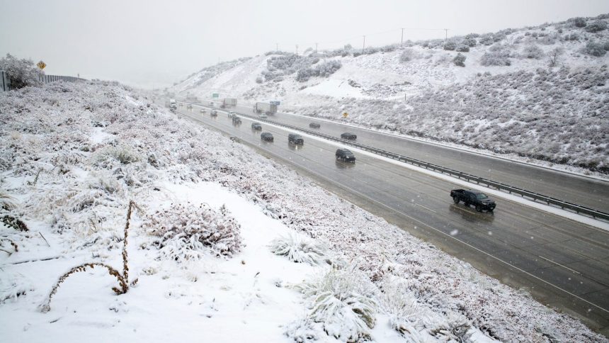
A major highway linking California and Oregon fully reopened late Wednesday, nearly 24 hours after a major storm blew in off the Pacific Ocean and slammed the region with heavy snow, gale-force winds and drenching rain. (Nov. 27)
AP
Meanwhile, the second, powerful storm in the Northwest, which had been dubbed a “bomb cyclone,” forced the shutdown Wednesday of 100 miles of Interstate 5 between Yreka and Redding in Northern California because of cars spinning out, according to CalTrans.
A “bomb cyclone” is a rapidly intensifying winter storm that is triggered by a precipitous drop in atmospheric pressure. This one on Tuesday in Northern California trapped many travelers on the road for hours, and some spent the night in their cars.
Give thanks! How Thanksgiving gratitude may improve your health
Christina Williams of Portland, Oregon, told the Associated Press it took her and her 13-year-son 17 hours to reach Redding, a trip that usually takes seven hours.
Williams said she and other stranded drivers connected on Twitter using weather-related hashtags and began to communicate to find out what conditions were like in other parts of the backup.
“There were spinouts everywhere. There were trucks that were abandoned. And every time we stopped and started moving again, there were people who couldn’t start moving again,” Williams said. “Every time we stopped I was like, ‘Is this it? Are we going to be here overnight?’”
Forecasters said heavy snow is likely through the end of the week from the
Sierra Nevada to the central and northern Rockies, with 1 to 2 feet of snow in many of these areas.
By Friday, as the storm moves eastward, snow is forecast to develop across the northern Plains, where winter storm watches are now in effect.
#GOESWest recorded an intense #BombCyclone that formed off the coast of #Oregon and Northern #California on 11/26/2019. Heavy #snow, strong #winds, freezing #rain, & coastal #flooding will likely impact #Thanksgiving travel plans in some areas. Stay safe! https://t.co/gy5rPRZvTMpic.twitter.com/jtK6BlTpMv
— NOAA Satellites (@NOAASatellites) November 27, 2019
Autoplay
Show Thumbnails
Show Captions
Read or Share this story: https://www.usatoday.com/story/news/nation/2019/11/28/thanksgiving-weather-snow-storm-moving-east-sunday-travel/4325127002/