On Tuesday afternoon, flood warnings were issued for 7 million people along Florida’s east coast, ahead of heavy rain predicted Wednesday and Thursday.
The flood warning extended from Cape Canaveral to Miami, encompassing Melbourne, West Palm Beach, and Fort Lauderdale.
Beginning Tuesday morning, major forecast models began indicating the possibility of a narrow axis of heavy rain producing 6 inches or more of rain somewhere along the metropolitan I-95 corridor, notably between West Palm Beach and Miami.
An region of converging air known as an inverted trough entering South Florida from the Bahamas will be the first ingredient in the recipe for a potentially large rain storm. Showers and thunderstorms are triggered by inverted troughs.
Related Posts

The location of the heaviest rain will be difficult to anticipate, and will be determined by where a slow-moving frontal barrier rising north from the Keys may form over the region. This boundary, particularly if it pauses, will concentrate an area of slow-moving thunderstorms, which might train over the same region for hours at a time, causing flash floods.
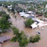
Heavy rain, storms, and onshore winds that coincide with high tide might exacerbate flooding problems.
Florida meteorologists were also warning Tuesday morning that such conditions are historically conducive for substantial rainfall events, which may generate high rainfall rates (1 to 2 inches per hour) and large volumes of rain (6 inches or more) in a few of hours.
As of Tuesday afternoon, the major prediction models were still indicating the possibility of a highly localized region between West Palm Beach and Miami receiving 6 to 12 inches of rain by Thursday afternoon.
Meteorologists underlined that it is hard to pinpoint the specific spot that would receive the highest rainfall totals, but if the elements come together just so, the rainfall rates may inundate infrastructure and cause dangerous travel conditions if highways flood.
That region of Florida does not require rain, as the eastern half is drought-free.
Fort Lauderdale is no stranger to heavy rains, including one this year. On April 12, the airport’s official reporting station recorded 22.5 inches of rain in one day. Other areas in the vicinity received up to 25 inches of rain. The previous record for the wettest calendar day, 14.59 inches, was set on April 25, 1979.
That event is also responsible for Fort Lauderdale’s wettest year on record, with 98.25 inches of rain thus far. To date, this is 41.91 inches over normal.